
Backpacking the Wonderland Trail was quite the adventure; full of ups and downs, and completely at the mercy of her… Mount Rainier. The 93 mile Wonderland Trail, goes around the entire base of Mount Rainier. Completing the trail was quite the personal accomplishment for me. The following is comprised of how I prepared for the trail, and my trail journal – the good and the bad!
Wonderland Trail Journal
Date: 9/1/2016 – 9/9/2016
Distance: 93 miles
Total Elevation Gain: 22,000 feet
Direction: Counterclockwise

Hiking the Wonderland Trail: The Complete Guide to Mount Rainier’s Premier Trail. This is a wonderful how to book! I used this book to plan my entire trip. It will tell you everything that you would want to know, including permits, food caching, where to start, elevation gain and loss, going counterclockwise vs clockwise, gear suggestions, weather, and much much more! I highly recommend buying this book! Purchase it on Amazon for $17.00, just visit the following link: https://www.amazon.com/Hiking-Wonderland-Trail-Complete-Rainiers/dp/1594856540/ref=sr_1_1?ie=UTF8&qid=1476038111&sr=8-1&keywords=hiking+the+wonderland+trail
Permits
Permits for the Wonderland Trail are typically obtained through a reservation permit system, and must be applied for, months in advance. However, the permit system for the reserved permits in 2016, failed; those who had applied and obtained permits for the 2016 season, lost their permits. Unfortunate for those individuals, but fortunate for those who did not have permits, for it then became a walk in permit system. So, this year, 2016, was definitely the year to cross it off the bucket list. With that being said, I made sure to schedule enough time off, after my travel nurse contract, to complete the Wonderland Trail. I walked into the ranger station on August 30th and was able to secure permits for the Wonderland Trail; although I did not get the permit schedule that I wanted, I got permits. That was all that was important!
I am not sure how the permit system will change for future years, but I know they are working on a new system for obtaining permits. For more information on obtaining permits for the Wonderland Trail, visit the Mount Rainier National Park Website at https://www.nps.gov/mora/planyourvisit/wilderness-permit.htm
Food Caching
There are three areas where food caches can either be mailed, or delivered to. I wanted to use all three food caches, but with how my wilderness permits worked out, I was only able to use two of the three; at Longmire and Sunrise. After completing the trail, I realized that the use of only two of the food caches was just right; three might have been too many, depending on how many days you are on the trail. I purchased three, five gallon buckets from amazon for fairy cheap. I planned out how many days of food would be needed in each bucket. I followed the guidance in the above mentioned book, by placing my name, permit number and intended pick up date, on each of the buckets. Keep in mind, if delivering the buckets yourself, it is an all day event. I delivered both buckets to their locations and headed to my starting point, Mowich Lake, which all together, was about 7-8 hours of driving from Seattle.

Day 0
Date: 8/31/2016
Location: Mowich Lake Campground
Weather: 50 degrees, raining
Time Arrived: 5 pm

I had mixed emotions upon arrival to Mowich Lake Campground. This was my first multiple day, solo backpacking trip, so I was a bit nervous and excited. I got my pack out of the car and walked to the walk up camp site. As I am putting my tent up, it was sprinkling quite a bit, so trying to keep everything dry and not run back to my car and quit before I even started, was quite a challenge. The rain continued, and the fog rolled in, swallowing the campground. I sat in my crowded, 1 person tent, sharing the space with my spread out gear and pack, trying to keep my motivation. I gathered my sawyer squeeze and water bottles, and decided to go filter water.
On my way back, I ran into a group of people, taking shelter by the toilets. I asked if I could join them, and we chatted for a bit. This was an interesting group of individuals. They lived to backpack. They would work 3 months or so, out of the year, and then hit the trail again. I learned a lot from them, and they convinced me to take several items out of my pack, including my Canon DSLR camera and extra lens, along with my hammock. Although sad at the time, I was thankful I removed these items as the rainy days passed.

As I snuggled into my sleeping bag, listening to the rain drops against the tent, I was thankful to have dry clothes; although, I couldn’t find my blow up pillow, which I was rather sad about. I realized I was definitely going to have to work on my organizational skills.
Day 1
Date: 9/1/2016
Location: Golden Lakes Campground
Weather: 38 degrees, raining
Distance: 10 miles
Elevation: 4700 feet

The day started off great. Initially, it was perfect hiking weather; it was cool and still a bit foggy, but perfect.
However, with only 2 miles left, it started to rain. My body was not quite accustomed to the elevation gain and loss, nor had I hiked in a couple weeks, so when it started to rain, I just kept going. Well, I kept going… until I ran into a black bear that is.

I had just passed a family of 4 and was moving quickly, approaching a lot of bear grass and blueberry bushes, when all of a sudden I see a adolescent black bear standing in the middle of my path. I stopped, and tried to remember what I am supposed to do. Although I have been taught to make noise and not startle the bear, I thought by making noise, I would startle the bear, so found that to be rather counter productive. I quietly turned back, and started walking in the direction that I just came from, to meet up with the family of 4 again, whom I call my bear protectors. I informed them of the situation and asked if I could walk with them. We approached the bear again and he crossed the trail, descended about 20 feet from the trail, and continued to eat the black berries. I stopped to watch the bear, who was not interested in us at all; he didn’t even look up. He had a big gash on his back, revealing the flesh beneath the hair. I wondered what could have possibly attacked the bear. I parted ways with my bear protectors and continued on my trek.

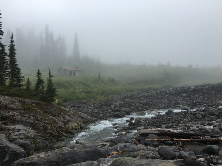
I soon came upon the ranger cabin at Golden Lakes Campground and was welcomed by two gentleman sitting on the porch, taking shelter from the rain, trying to stay warm and dry.

They were hopeful that a ranger would come soon, and I assured them that I passed the ranger who was staying at the cabin that night and he was very friendly. I went to set up my tent, and wandered back to the ranger cabin to the smell of a fire and my new Golden Lakes friends inside. The ranger was kind enough to let us in the for the majority of the evening.

We sat by the wood burning stove, giving our socks and shoes time to dry, eating our dinners, and staying warm. The darkness approached quickly and we parted ways to our individual tents.
As I hurried to get into my tent, out of the rain, I sat on my sleeping pad, once again crowded by my gear, thankful that I had warm, dry clothes to put on. It was pretty cold, so I threw some hand warmers down by my feet and forced my sore body into my sleeping bag. I found my pillow; that was exciting! Shortly after I closed my eyes, I drifted off to sleep, but tossed and turned throughout the night.
Day 2
Date: 9/2/2016
Location: Klapatche Park Campground
Weather: 39 degrees, raining
Distance: 9.78 miles
Total Distance: 19.78 miles
Elevation: 5600 feet

Soon after the sun came up, the soreness of my body, and the sound of rain woke me. I decided to get my sore muscles moving and get out of my warm sleeping bag, to conquer packing up my gear and wet tent. After taking some Advil, and eating one of my biscuits and gravy meals, I filtered some water and made my way back to the patrol cabin. I chatted with my new friends from the night prior, before we all decided that the rain was not going to let up, and to part ways.


One of my new friends, was a tall, white haired older gentleman, whom I like to call the BFG (Big Friendly Giant – for those of you who are Roald Dahl fans), and he was headed my direction, so we decided to hike together for the day. BFG is a newly retired guy, with a wife and two daughters, completing his bucket list hikes, including the AT next year.


It rained for almost the entire hike. I continued praying for the rain to stop.

While hiking, we came to a beautiful canyon with a large waterfall. Would it have been better had the sun been shining, probably, but I was very thankful that it was clear enough to see the waterfall, with the canyon walls behind it.
After climbing several thousand feet, I didn’t know if I could make it anymore. My feet were so swollen, I thought they were going to bust out of my shoes. My legs were beyond feeling like jello.

Just when I was losing hope, the sun came out and I could see blue sky through the clouds.

God is great. I could finally see the spectacular views and was able to push myself to get to camp.

BFG and I had split up quite some time ago, but we brought together again at camp, in the beautiful weather.
The sun was only out for a short bit, before the clouds came in again. I hurried to throw my tent up. I was again thankful for dry clothes, a warm sleeping bag, and God, who gave me enough sunshine to give me hope, get me to camp and put my tent up, before the rain. I even put up my Christmas lights up.
Day 3
Date: 9/3/2016
Location: Devil’s Dream Campground
Weather: 40 degrees, mostly cloudy.
Distance: 12.18 miles
Total Distance: 31.96 miles
Elevation: 4900 feet

It looked like it was going to be a spectacular day. When I opened my tent, first thing in the morning, I saw her. Mount Rainier was staring right at me through my tent window. She had been there the entire time the day prior, but covered in clouds.

The sun was rising behind her at the beginning of the hike, but it wasn’t long before the clouds started to roll in, so that was the last time she showed her face the rest of the day. It was very unfortunate because today would have been yet another great days for awesome views.

Today was a lot of hiking large elevation gains and losses. It was quite an exhausting day. After passing North Puyallup River, there was a super high, one person suspension bridge we had to cross.


As I walked across, the bridge wobbled slightly with each step. When I mistakenly looked down, a large white River was gushing through a very steep canyon.

As soon as I slowly made my way over the bridge, it once again started to drizzle. My spirit was brought down quite a bit with the unexpected weather change. Without sun for several days, I was unable to charge my solar panel, so that was also a bit frustrating.
Devils Dream was in the middle of the forest, without a view of the sky, and the mosquitos were biting. So, once again, I quickly had dinner and retired to my tent for the evening. My body was slowly becoming accustomed to the level of exertion, and I was surprisingly less sore.
“Goodnight Journal and whomever finds themselves reading this in the future, tomorrow will be a brighter day!”
Day 4
Date: 9/4/2016
Location: Paradise River Campground
Weather: 58 degrees, sunny
Distance: 10.29 miles
Total Distance: 42.25 miles
Elevation: 3900 feet

BFG and I got going again and I was so excited, because today was the day we made a pit stop at Longmire. We arrived at 0950, and it was like I hadn’t had real food in years, because I had a Pepsi and it tasted so amazing. I also had French Toast, bacon and eggs. I saved some of the French toast and bacon for the trail. The waitress (Chris) and staff at the National Park Inn restaurant were so friendly. I cannot say enough good things about the staff and how I was treated. I picked up my food cache, stuffed everything in my pack and went back to the Inn to eat a big juicy cheeseburger before the BFG and I headed out on the trail again.

Most of the hike was in the forest today, which I am not really a fan of forest hiking. However, the sun was shining and that was awesome. After picking a secluded cozy wooden camp spot, I set up my tent and hung my clothes to dry. I then made my way back to the river.

I sat in my bathing suit, on a big wooden bridge, barefoot, with my feet hanging over the bridge, in full sunlight. The water was flowing beneath the bridge, and the glorious sound of running water was music to my ears. My solar panel was sitting by my side, enjoying the sun as much as I was.

God is great. Just when your spirits are running low, he recharges you. This day, was exactly what I needed.
Day 5
Date: 9/5/2016
Location: Nikel Creek Campground
Weather: 72 degrees, sunny
Distance: 10.68 miles
Total Distance: 52.93 miles
Elevation: 3350 feet

Day 5 was yet another tough day. I got to camp at the end of the day, unbuckled my pack, which felt 50 lbs heavier on this day for some reason, and put my tent up. Hunger overcame me and I hurried to boil water. I scarfed down biscuits and gravy, a pastry, and an extra large rice crispy treat. I took every ounce of energy I had left, to blow up my sleeping pad, then I sluggishly crawled into my sleeping bag around 2pm. My feet were throbbing, my right posterior hip/buttock area aching and shooting pain down my right leg, my eyes were heavy and my face was burning up. I thought surely this pain would slow my down on the subsequent days, but my eyes were too heavy to care. Within seconds, my exhaustion won the battle and i was sound asleep.

I abruptly regained consciousness at 445pm. I made my way to BFG’s camp and noticed that my bear protectors were also set up camp at this camp ground. Everyone was setting up, in anticipation for the rain, in which I was in denial about. For the first time, since day one, all of my gear was dry. I wasn’t looking forward to fighting the rain again. However, to my surprise, my body was back to normal and I was free of pain. I was so thankful for that.
A lot of day 5’s hike was in the forest, but the parts that were not covered by tree branches, were gorgeous.

We passed Reflection Lakes and were able to see Mount Rainier again.


We also hiked down Steven’s Canyon, which was really gorgeous, especially with the sunshine. Parts of the trail were really narrow in the canyon. As we hiked down into the canyon, signs of fall were showing on both sides of the canyon. We passed 3 waterfalls, one of which, we walked right in front of. 0.8 miles before camp, we crossed Box Canyon, which reminded me of the gray slot canyons in the Southwest, except with a very fast moving river running through it.
Today marked the half way point for me! The half way point for me, was very sentimental. It made me realize that I really was capable.
Day 6
Date: 9/6/2016
Location: Indian Bar Campground
Weather: 75 degrees, cloudy, raining
Distance: 6.65 miles
Total Distance: 59.58 miles
Elevation: 5101 feet

On day 6, I was thankful for: God; a dry, warm sleeping bag; dry clothes; company with BFG; Ramen Noodles; the little sun and views we did have today; Christmas lights; wildflowers; the photos to remember this trip; the technology that has gotten me as far as it did; rain paints; rain jacket; my umbrella; cold water; and the shelter at Indian Bar. I had to start with things I was thankful for because day 6 was such a crappy day.
I didn’t sleep well the night before. The rain kept me up the night before. I also kept hearing chipmunks outside of my tent and thought they were bears. I know, a ridiculous thought, but our minds are powerful persuaders, when it comes to fear. I was going over what I would do if a bear was out there. I had my knife handy and i would scream for BFG and my bear protectors. However, there wasn’t a bear and I was fine.
People rage about the hike to Indian Bar and that Indian Bar is the prettiest of the campsites.

I can only imagine how pretty it would have been, had we not been in white out conditions the entire day.
I tried so hard to stay positive, but the entire week had been pretty soggy, wet and cloudy.

We spent the majority of the day in the gorgeous shelter at Indian Bar with my bear protectors, who eventually continued on and we said our farewells.

We were told that campsite 3 had the best view, and although we got there early enough to pick our own campsite, there wasn’t much of a view with the clouds hiding the view. Eventually, BFG and I set up our tents and called it a night, hoping that the next day would bring brighter, bluer skies.
Day 7
Date: 9/7/2016
Location: Sunrise Campground
Weather: 33 degrees, slightly raining/sleeting into the night
Distance: 16.27 miles
Total Distance: 75.85 miles
Elevation: 6245 feet

We woke up, on day 7, to yet another chilly, gray, and drizzly morning. Day 7 was the big day… going over Panhandle Gap. It is known that the Panhandle Gap can be difficult to navigate and it was easy to lose the trial. GPS in hand, I wasn’t too worried about getting off track.


We started early and once again, it was white out conditions with light showers every so often. At times, we could barely see 30 feet in front of us. Even with these conditions, the trail was never hard to navigate.

Once passing over the Panhandle Gap, it was almost like walking through a door. In front of us, blue skies, sunshine and a breathtaking view; behind us, grey skies and no visibility.

The excitement ran through my body, eager to go further to get a glimpse of Mount Rainier again. This was my second favorite part of the trail; from Panhandle Gap to Sunrise. It was just so spectacular. Plus, the sun was shining.

We stopped at Summerland Campground for lunch, which was a beautiful campground. If you are unable to take the time to do the entire Wonderland Trail, I highly recommend doing Sunrise to Indian Bar (clockwise).

I was pretty eager to get done with the trail, so I was able to rearrange my schedule with a very nice park ranger, so that I would finish in 9 days, and not 11. I had a very long couple of 15+ mile days ahead of me though.
BFG and I parted ways several miles after Frying Pan Creek. It was already late in the afternoon and I had several thousand feet to climb still, and several miles to go. It was strange being alone for the first time in several days.

However, I wasn’t alone for very long before I ran into yet another bear. I had my head down, looking at my GPS and when I looked up, not 20 feet in front of me, a black bear stood crossing the trail. I stopped dead in my tracks, slowly backed up. He continued on, without even making eye contact with me. He didnt’ see to be interested in me anyways.

I arrived at Sunrise Campground at dusk, and it was very very cold and windy. I hurried to put my tent up and shoved my sore body into my sleeping bag, falling into a deep sleep.
Day 8
Date: 9/8/2016
Location: Cataract Valley Camp
Weather: Sunny
Distance: 15.26 miles
Total Distance: 91.11 miles

I woke up before sunrise to go 1.4 miles off trail to pick up my last food cache. I didn’t realize that it was a 3 mile round trip to pick up the food cache, or I would have picked it up the night prior.


The sunrise was surely my favorite sunrise of the trip, and day 8 was my favorite day. The views of Mount Rainier were so awesome. The pictures don’t do it justice, but I don’t have to write much about today, because the pictures say it all!

Yet another gorgeous suspension bridge. I was very impressed with the architecture of the suspension bridges and how safe they were… However, I was still scared sh**less to go over them!

Prior to changing around my schedule, I was actually suppose to stay at Mystic Lake. After passing by it, touching my fingertips to the warm lake water, I was a little sad I wasn’t stay thing. After all, I did bring a pink floaty, I had yet to use. The thought of a bed and burger were much more appealing at the moment, so I kept going. One heavy foot in front of the other.


Did I mention the amazing views of Mount Rainier on day 8?!
Day 9
Date: 9/9/2016
Location: Mowich Lake
Distance: 6.74 miles
Total Distance: 97.85 miles
Elevation: 4929 feet
There are two routes that go back to Mowich Lake: Ipsut Creek and Spray Park. The “real” and complete Wonderland Trail is to take the Ipset Creek route. However, that route claims to be washed out.

Plus, I had also heard rumors that Spray Park was like a fairy tale, with stunning views, mountain goats, wildflowers and lakes. Which route to take, wasn’t that hard to choose.
Both routes are almost the same miles, and both are still circumferential to Mount Rainier, so whichever way you take, you still have completed the Wonderland Trial; although, others might argue this. Those people are probably just grumpy they didn’t take the prettier, better option.

It was such a clear day, you could see mountain range, after mountain range. So awesome.

And more views of Mount Rainier… Of course.
Although day 9, was only a 6.74 mile day, it was the longest 6.74 miles of the trip. I was so excited to get back to the car, to shower, and to sleep in a bed. The last 2-3 miles of the hike, on the way back to Mowich Lake, was in the woods, but I wasn’t complaining. The less there was to look at, the less distracted I would get, and the sooner I would get back to the car.

However, I did make one pit stop at Eagle Crest View Point, for one last view of her… before I got off the trail.

I was practically running the last two miles. Eventually, I did make it to the car and I definitely felt very accomplished and proud of myself. This gave me the confidence I needed to know that I can and will hike the Pacific Crest Trail.
I did it! I am a Wonder Woman!

Just found this blog! Just got my permit for 2017 and I’m so excited. Glad I found another female on her first solo backpacking trip. I’m nervous, but relieved that you had such a great trip. Great post – thanks for all the info!
LikeLiked by 1 person
My pleasure!! If you have any questions, please feel free to ask!
LikeLike
Good luck and have a blast!!
LikeLike
Found your blog while doing my annual search of PCT hikers to live vicariously through until I can do it for myself. Looks like you started your Wonderland hike the same day I finished it. I’ll never forget my stay at the Indian Bar cabin….incredible experience. Enjoy your adventure on the PCT!
LikeLiked by 1 person
Was the weather good for you at Indian Bar?? I wish I had a view at Indian Bar. I’ll never forget my experience there either, but only because it was a little bit discouraging!
LikeLike
I was lucky the entire trip. Clear skies, plenty of views and great weather to relax in my hammock after a long day of hiking. Indian Bar was my last night before leaving the trail at White River on August 31. Clouds were rolling in throughout the morning and the rain started just as I reached my car. You had more bear sitings, though. I only saw one from a distance while I was at Indian Bar. I think we made a good call going last summer while the permit system was down. Something like 2500 people signed up for only 450 permits this year.
LikeLiked by 1 person
Another great blog! Thanks!, There are a lot of black bears in Western Wa. I have seen several in my hiking adventures. Generally speaking you don’t bother them they won’t bother you. I ran into a mom bear and cub not 10 ft off trail. Was awesome. I love bears. Anyway nkt bear expert but pretty close. Never run – goes without saying. For Black bears it is ok to make noise and make yourself larger. I seen bear run up hill from river in north cascades at full tilt and it is amazing to see. Unlike heights i am not afraid of bears. Grizzly bears you definitely act diiferent than around blacks. That being said you are more likely to be attacked by black but mainly due to numbers. If a black attacks you fight back. Black attacking wants to eat you. Grizz just is show of dominance either protecting cubs, a animal kill like elk, or you surprised it. Also grizz will bluff charge. I think you did the right things on wonderland trail. There are a very few grizz in north cascades but very very few and as long as you talk, sing etc they will be happy to get out of the way as they dont particukar like being around humans. Cant say i blame em. Sorry for getting into bear discussio .
Cheers!
Ps – posted video on my igram of mom bear and cub i ran into on snow lake trail last fall. I think your bears were bigger 😆
LikeLiked by 1 person